


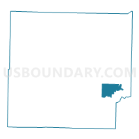
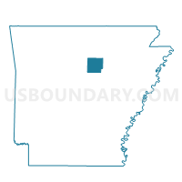
Pine Voting District, Cleburne County, Arkansas
About
Outline

Summary
| Unique Area Identifier | 526163 |
| Name | Pine Voting District |
| County | Cleburne County |
| State | Arkansas |
| Area (square miles) | 7.90 |
| Land Area (square miles) | 7.90 |
| Water Area (square miles) | 0.00 |
| % of Land Area | 100.00 |
| % of Water Area | 0.00 |
| Latitude of the Internal Point | 35.47608100 |
| Longtitude of the Internal Point | -91.87274640 |
Maps

Graphs
Select a template below for downloading or customizing gragh for Pine Voting District, Cleburne County, Arkansas


Neighbors
Neighoring Voting District (by Name) Neighboring Voting District on the Map
- McJester Voting District, Cleburne County, AR
- Mountain Voting District, Cleburne County, AR
- Pickens Voting District, Cleburne County, AR
- Sugar Loaf Voting District, Cleburne County, AR
- Wilburn Voting District, Cleburne County, AR
Top 10 Neighboring County Subdivision (by Population) Neighboring County Subdivision on the Map
- Mountain township, Cleburne County, AR (668)
- Sugar Loaf township, Cleburne County, AR (602)
- Pickens township, Cleburne County, AR (531)
- McJester township, Cleburne County, AR (463)
- Wilburn township, Cleburne County, AR (350)
- Pine township, Cleburne County, AR (262)
Top 10 Neighboring Unified School District (by Population) Neighboring Unified School District on the Map
- Heber Springs School District, AR (11,984)
- Concord Public Schools, AR (4,463)
- Pangburn School District, AR (3,447)